Monsoon is the time of year many of us look forward to as active weather moves into the forecast! So what exactly is the “monsoon?" Below is a post we put together several years ago, to help people better understand the basics of the monsoon. Enjoy!
Before looking at how the monsoon works, one must understand the definition of monsoon and what it encompasses.
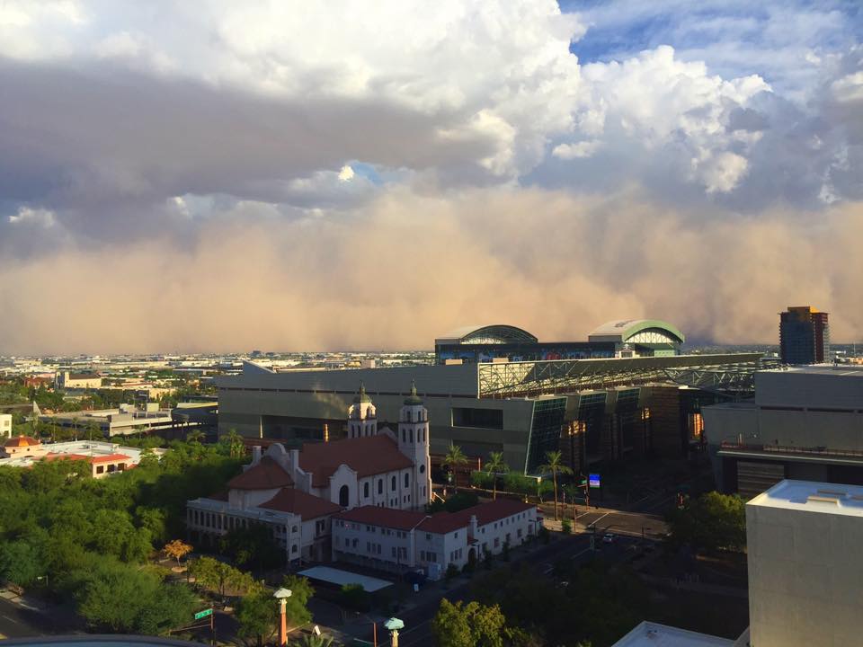
The word monsoon comes from an Arabic word “mausim” which means season (*2). This particular season does not correlate to the position of the sun but, instead, deals with a wind shift. In the desert Southwest, during the monsoon, the wind will shift from a normal westerly wind direction to a more southeasterly/southerly direction. This sets up a weather pattern that we will discuss in more detail later on, but for now, realize that it can import moisture into the state leading to widespread thunderstorm activity.
 An important thing to remember is that a thunderstorm during this time is not a "monsoon." Thunderstorms that occur during the monsoon are called "monsoon thunderstorms" or simply thunderstorms.
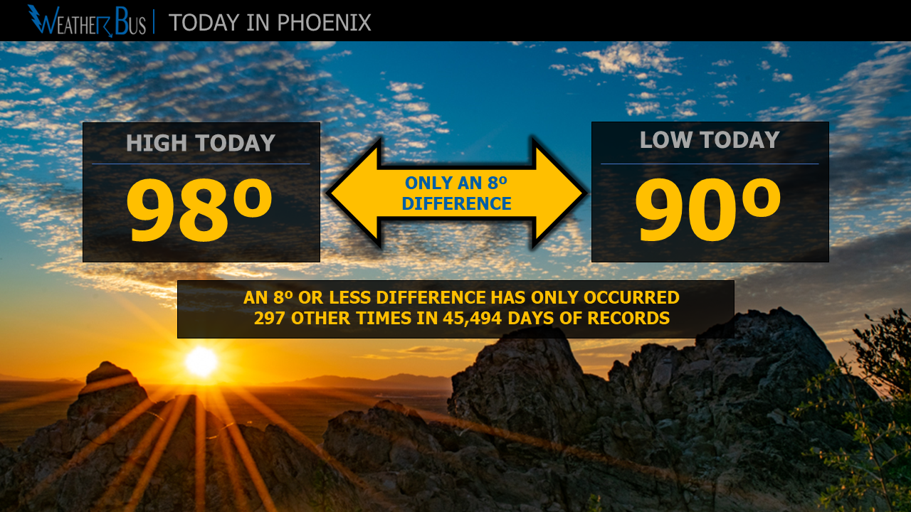
What signals the official start of the monsoon? Starting in 2008, the Arizona monsoon is officially defined by a finite start and end date. Under this new “system,” the start date of the monsoon is June 15th, and it ends on September 30th.
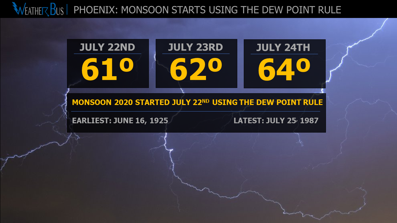
Before 2008, the season was defined to have started after a location had a daily dew point average of 55ºF or higher for three consecutive days. Using the old system, the average start date for Phoenix was July 7th, but it has started as early as June 16th in 1925 and it began as late as July 25th, 1987 (*6). Looking at Tucson data, the average start date was July 3rd. The earliest start date for Tucson was June 17, 2000, and the latest start date was July 25, 1987 (*11).
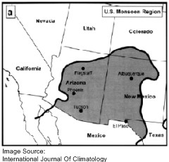 Every summer, the monsoon develops in the Southwestern United States. The area primarily affected by the monsoon can be seen in the image to the left, and it includes Arizona, Colorado, New Mexico, and a small portion of Texas (*3). Effects can go beyond this area, but for the most part, it is scientifically within this boundary. Phoenix is on the western edge of the monsoon area, which means the effects of the monsoon are a little less than that seen in Tucson and the higher elevations of Arizona and New Mexico.
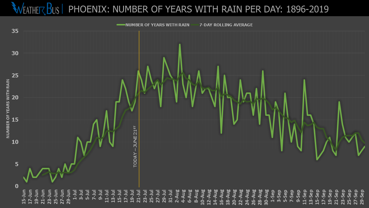
 The monsoon pattern usually begins to set-up in June and ends in September (*4). Phoenix, however, due to its location, usually begins to see the effects of the monsoon in the beginning part of July.
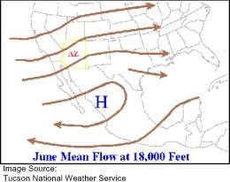
Looking at the June weather map, to the right, an area of high pressure develops over Mexico (*10). This setup allows Arizona to have the typical west to southwest wind pattern resulting in very little moisture being imported into the state. During this time as well, Phoenix and the surrounding desert locations experience scorching heat, which will eventually lead to the formation of a thermal low over the southwest portion of the state, which aids in the development of the monsoon pattern expansion.
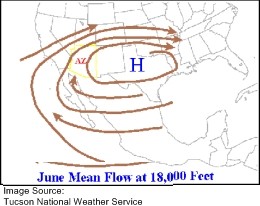 Looking at the July weather map (left), a much different situation can be seen. High pressure moves northward toward the end of June to the beginning of July and centers itself over different regions throughout the season including West Texas, New Mexico, and the Four Corners region of Arizona. Also, as discussed earlier, a thermal low develops from the very hot temperatures around the Yuma area. Movement of this high pressure and the thermal low centered around Yuma changes the dominant wind direction in Arizona to the south/southeast. This change in wind direction allows moisture from Mexico, and the Gulf of California, to be imported into Arizona, New Mexico, and portions of Colorado. As high pressure drifts around, the moisture imported into the state will vary resulting in more thunderstorm development or less thunderstorm development.
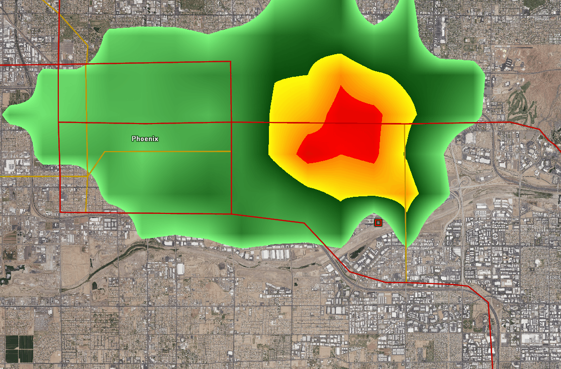
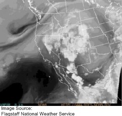 The monsoon can be enhanced or not present for a couple of days at times during the season. These enhancements in moisture or lack of moisture to the area are called bursts and breaks (*9). Looking at the water vapor satellite image (right), it shows a surge of moisture resulting in numerous thunderstorms across the state. To read this water vapor image, the brighter the white, the more moisture available.
There are six main ways that moisture can increase during the monsoon:
Upper Air Disturbances:
As upper air disturbances move through the area, stability increases. This, in turn, allows the coverage and intensity of thunderstorms to increase (*10).
Gulf of California Moisture Surge Type One:
These types of surges will typically occur if the thermal low centered near Yuma is intensifying due to an increase in temperatures in the desert, and a large complex of thunderstorms is happening over central Mexico. The outflows created by strong thunderstorms in Mexico, as they collapse, can increase the moisture levels throughout the entire state leading to increased thunderstorm activity the next day (*6).
 Gulf of California Moisture Surge Type Two:
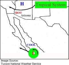
Another type of Gulf Surge is when a tropical system moves toward the tip of Baja or moves across Mexico from the Gulf of Mexico. This can import more moisture into the area increasing thunderstorm activity. (Image on left)
Thunderstorm Outflow:
Thunderstorm outflows are almost like the Gulf Surges, but on a more localized scale. Thunderstorms will develop in the higher terrain of Mexico and Arizona, and as the storms decay will send out a flow of cool/moist air. On the leading edges of these outflows, more thunderstorms can rapidly develop. (*8).
 Diurnal Flow:
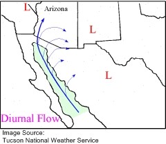
Diurnal flow is the daily flow of moisture from the Gulf of California into Arizona and Mexico. This does not have a large impact on Arizona, but it is one of the main contributors to the thunderstorms that develop in Mexico. This process does, however, have the possibility to increase the lower level moisture content throughout the area (*8). (Image on right)
Backdoor Front:
A backdoor front moving through Arizona can increase the thunderstorm activity as well. This occurs when a very weak cold front moves down from the northeast into the state. These systems can bring with them moisture in the lower levels of the atmosphere, resulting in an increase in thunderstorm activity throughout the state (*8).
Moisture Recycling:
Moisture recycling is a process of heat evaporating moisture on the ground created by rainfall from previous storms. This, in return, will increase the moisture content in the lower levels of the atmosphere providing more moisture for thunderstorm development. This occurs mainly in the mountainous areas of Arizona and Mexico but can occur in the valley as well under certain circumstances (*8). (Image on right)
Those are the six main ways moisture can increase in the state, but throughout the season, the moisture can decrease as well.
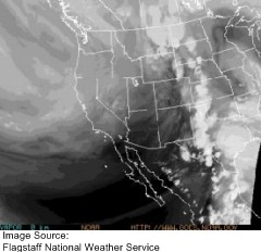 The water vapor image to the left shows a break in the monsoon. As can be seen, moisture has shifted to the east over western Texas. This results in Arizona and Northern Mexico being extremely dry with little to no thunderstorm activity (*9).
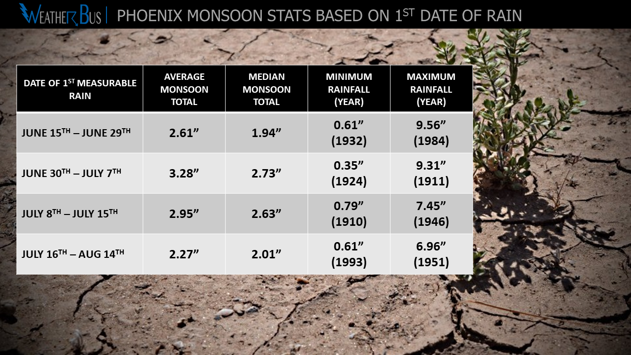
A final main component to discuss when dealing with the monsoon is rainfall. Rainfall throughout the state during the monsoon changes dramatically with elevation. This is mainly due to orographic effects caused by the mountains in Arizona’s high country (*5).
Highest average rainfall for Arizona during the monsoon is 11.46 inches, which is recorded in Greer. Lowest average rainfall is registered in Yuma with only 1.01 inches. Phoenix on average measures 2.71 inches.
As can be determined from this brief introduction to the monsoon, the season is very complex. If you have any questions, feel free to contact us or tweet @mattpaceweather.
Sources Used:
1. Arizona Climate Summaries, Western Regional Climate Center,
http ://www.wrcc.dri.edu/summary/climsmaz.html
2. The Arizona Monsoon, NWS Forecast Office in Phoenix, Arizona,
http ://www.wrh.noaa.gov/psr/general/monsoon/
3. Ellis, Andrew W., and Erinnanne M. Saffell, and Timothy W. Hawkins “A Method For Defining Monsoon Onset And Demise In The Southwestern United States.” International Journal Of Climatology 24 (2004): 247-265
4. Higgins, R. W. “Interannual Variability of the North American Warm Season Precipitation Regime.” Journal of Climate 12 (1999): 653-680.
5. Michaus, Jené D. “Spatial and Elevational Variations of Summer Rainfall in he Southwestern United States.” Journal Of Applied Meteorology 34 (1995): 2689-2703
6. Monsoon Information, NWS Forecast Office in Tucson, Arizona,
http ://www.wrh.noaa.gov/twc/monsoon/monsoon_info.php
7. Monsoon Statistics, ASU Geography Department,
http ://geography.asu.edu/cerveny/wxpart4.htm#monsoon2
8. Summer Thunderstorm In Arizona?, NWS Forecast Office in Tucson, Arizona,
http ://www.wrh.noaa.gov/twc/monsoon/az.php
9. What is the Mexican Monsoon, NWS Forecast Office in Tucson, Arizona,
http ://www.wrh.noaa.gov/twc/monsoon/mexmonsoon.php
10. What is the Monsoon?, NWS Forecast Office In Flagstaff, Arizona,
http ://www.wrh.noaa.gov/fgz/science/monsoon.php?wfo=fgz
11. Year-by-year monsoon statistics, NWS Forecast Office in Tucson, Arizona,
http ://www.wrh.noaa.gov/twc/monsoon/monsoon.php