Arizona: Exceptional Drought Returns

- Posted in Drought by

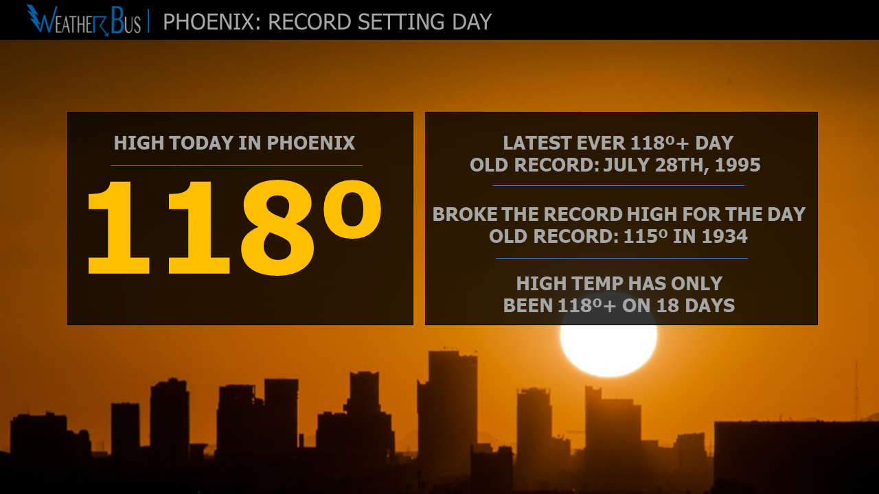
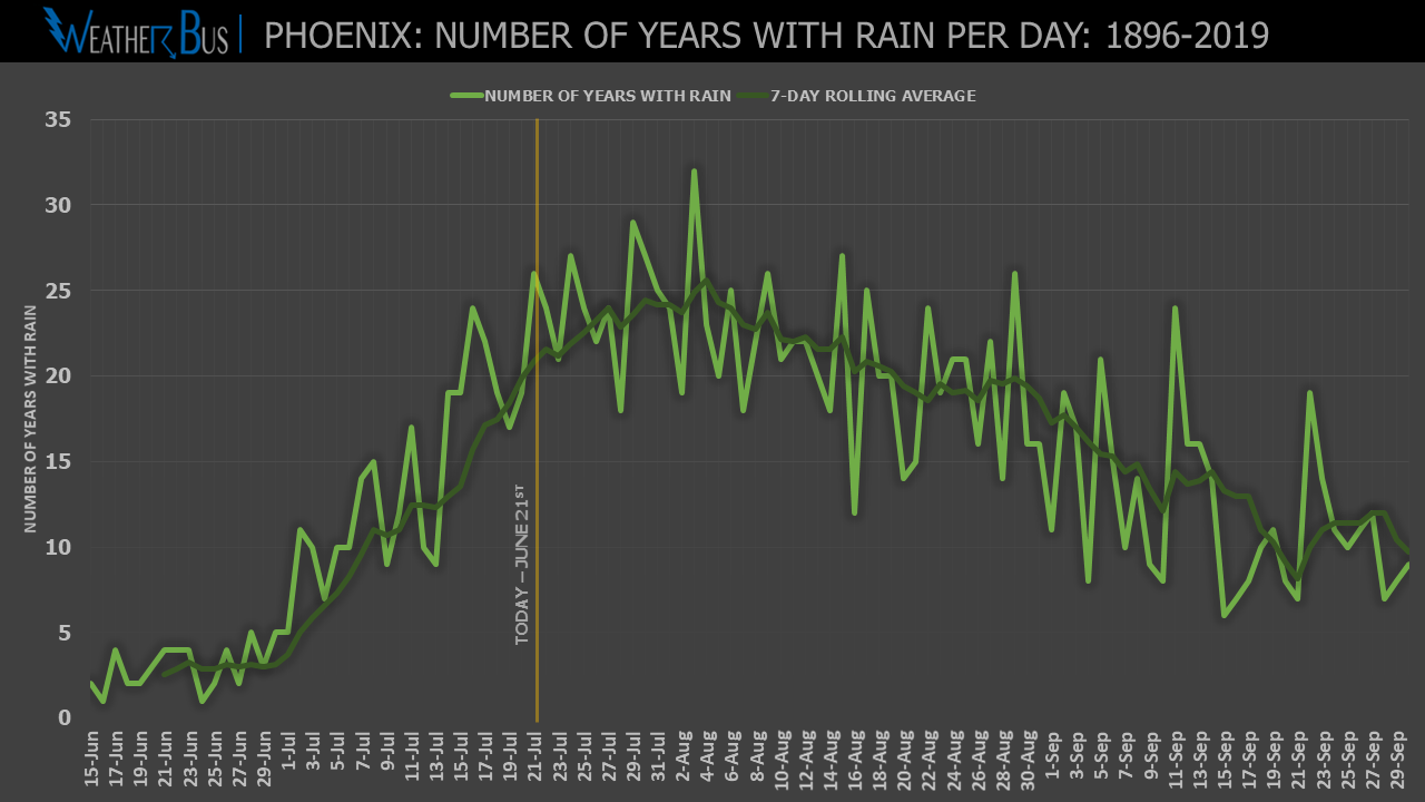
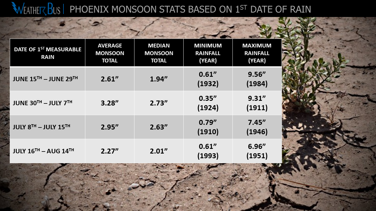
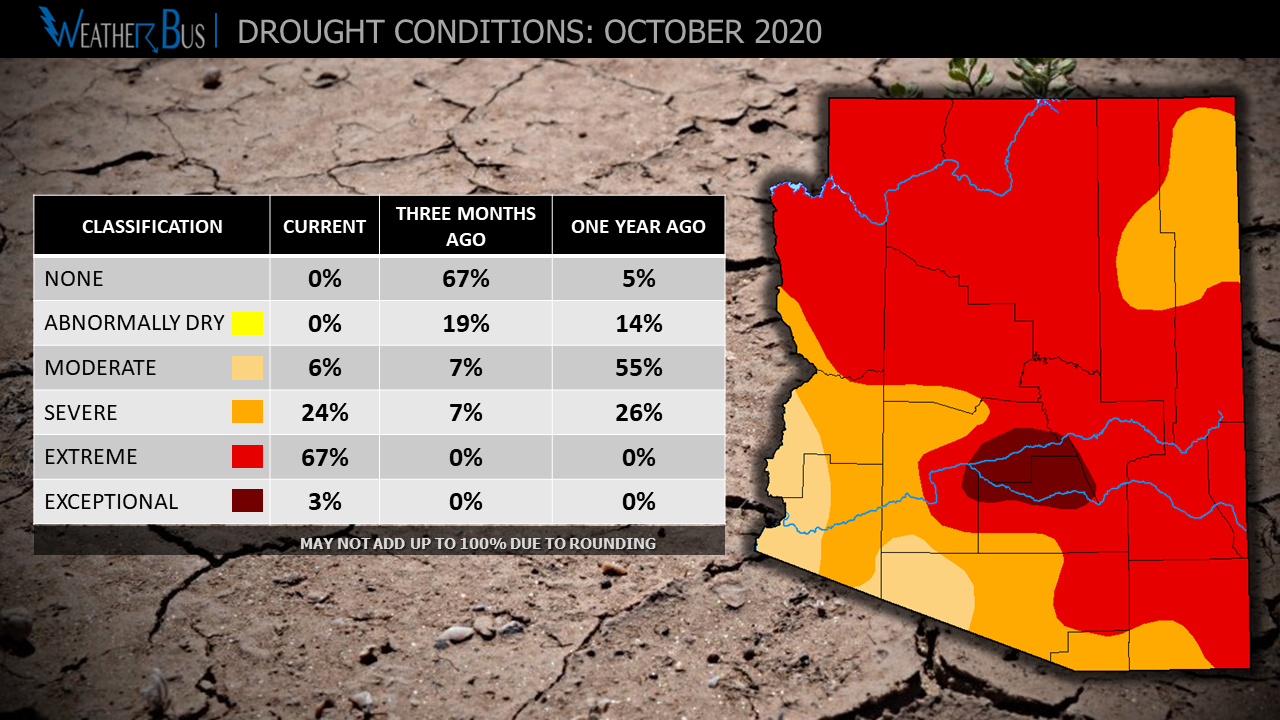
With a nearly nonexistent monsoon this year, it shouldn't come as too surprising that drought numbers are back on the rise across Arizona. Currently, 3% of the state is now in exceptional drought, which is the highest drought classification. Extreme drought covers another 67% of the state.

This is the first time since January 2019 that exceptional drought has been in Arizona. And further analysis shows that using the Drought Severity and Coverage Index, these are the worst drought conditions Arizona has seen since July 2018.

So any relief in sight?

Unfortunately, there is no rain forecast in the near term. Looking longer-term, with La Nina conditions expected through the winter, the Climate Prediction Center has a 40-50% chance of having below-average rainfall this winter.

With very dry conditions around the state, be sure to use extreme caution with any open flames or activities that may create sparks as fire danger remains elevated.

Phoenix Sets New Record For Number Of 115º+ Days

- Posted in Weather Records by

On August 14th, Phoenix Sky Habor reached a sweltering high temperature of 117º. This not only tied the record high for the day but also brought the number of 115º+ days so far this year to 8. The record number of 115º+ days in a year was 7, set back in 1974, so we have indeed passed that.

And if you are keeping track, we are now at 38 days at or above 110º this year, which smashes the old record of 33 set back in 2011.

Will Monsoon 2020 In Phoenix Stay Dry?

- Posted in Monsoon by

Believe it or not, we are now past the halfway point when it comes to Monsoon 2020. So far this season (June 15th - August 12th), Phoenix Sky Harbor has measured a meager 0.10" of rain. This year now ranks as the second driest monsoon during this period, with the record driest going to 1995, when no rain fell until August 14th!

With the first half of the season being so dry, could we see a wet end to the season? Let's go to the data!

Back in 1995, at this same time, we had no rain; however, from August 13th - September 30th, an additional 7 days of rain was recorded with the monsoon total ending up at 4.58", which is well above the average of 2.71". So just because we start dry, we don't have to end dry!

Now, before you get too excited, let's look at the averages from the top 20 driest monsoons (June 15th - August 12th). On average, there are six days of rain between August 13th and September 30th, resulting in an additional 1.56" of rain. Using this average, it would leave Monsoon 2020 in Phoenix at 1.66", which is over an inch below the average.

Looking at the worst possible situation, no rain has fallen during the last half of monsoon in 1973 and 1945, which would leave Phoenix as 0.10". This would undoubtedly break the record for the driest monsoon on record.

On the flip side, in 2014, Phoenix received 5.84" of rain in the last half of monsoon, with 3.3" falling in just one day as moisture from a tropical system moved into the region.

So while odds are certainly leaning toward a dry end to Monsoon 2020, don't let your guard down thinking there will be no more storms in the Valley of the Sun. There are some indications that tropical activity in the East Pacific could increase later this month into September, which could help to bring plenty of moisture to the state. After all, it really only takes one good storm to get us right back to average or even above average.

Keep thinking rain!

Phoenix: 34 days of 110º+ and counting

- Posted in Weather Records by

Feeling hot? You are not alone!

On August 9th, Phoenix Sky Harbor broke the 110º mark for the 34th time so far this year! This breaks the old record of 33 days, which was set in 2011. The average number of 110º+ days stands at 19.

Keep in mind, the Valley of the Sun broke this record on Aug 9th and the average last 110º+ day is not until August 26th, so still plenty of time to rack up more very hot days. In fact, looking at the current forecast, the tally this year could be at 40 days by the end of next weekend.

Stay cool!

Phoenix Hits 115º+ Four Days In A Row

- Posted in Weather Records by

No getting around it, the Valley of the Sun has been incredibly hot this week. In fact, the high temperature at Phoenix Sky Harbor has been 115º+ for the past four days (July 28th-31st).

This ties the record for the longest streak of days at or above 115º, which has only happened four other times since records began.

June 19-22, 1968

June 25-28, 1976

June 25-28, 1990

July 26-29, 1995

Phoenix: Record Setting 118º!

- Posted in Weather Records by

The high temperature at Phoenix Sky Harbor at 4:40 pm on July 30th hit a sweltering 118º. This broke the record high for the day of 115º, set all the way back in 1934. But this was not the only record broken.

This will now go down as the latest day in a year with a high temperature of 118º+. The old record was July 28th set in 1995.

And yes, having a high temperature of 118º is very rare. In fact, since records began in 1896, the high temperature has only been 118º+ a total of 18 times!

Monsoon 2020 Starts In Phoenix

- Posted in Monsoon by

Since 2008, the monsoon has had fixed start and end dates of June 15th to September 30th. Before these dates were established, the monsoon was defined to have started in Phoenix when the daily average dew point was 55º or higher for three consecutive days.

Over the past three days (July 22nd-24th), Phoenix has recorded a daily average dew point of 55º or higher, so Monsoon 2020 started using the dew point method on July 22nd! The earliest start date was on June 16, 1925 and the latest occurred on July 25, 1987. On average, the start is around July 7th.

Even though this rule is not the "official" way to determine the start of the season, I still like to track it!

Phoenix Dry Streak Has Ended!

- Posted in Weather Facts by

Monsoon storms finally moved over Phoenix Sky Harbor just before 7 pm on July 24th, producing 0.10" of rain, breaking the 103 day long dry streak! The last time measurable rain fell at Sky Harbor was April 11th!

So far this year, 3.65" of rain has fallen, which is below the year-to-date average of 3.95".

The radar image above shows how close the storm came from missing the rain gauge at the airport, marked with the red box.

July 23, 2020: Rare Phoenix Temperature Event

- Posted in Weather Facts by

*****NOTE: The temperature after this post was written dropped to 86º at 11:59pm. This means the difference in high/low for the day was 12º, which has happened 1,262 times. Not nearly as impressive as only 297 times.***

If you are looking for a dose of random weather facts, you have come to the right place. Today it's all about the high and low temperature difference! And there is one fact that I think weather nerd or not, you will find interesting!

The high temperature at Phoenix Sky Harbor on July 23, 2020, was 98º, with a low of 90º. That's a difference of just 8º. Having a temperature range that small has only occurred 297 times since records began in 1896. In other words, in 45,494 days of weather records, it has only happened on 0.65% of the days!

Ok, now to the very strange part!

Having an 8º difference has only happened five times in July since records began. Ok, great, not that exciting... well, just wait... out of those five times, three have occurred on July 23rd! Very interesting, don't you think? Slim odds of that happening!

Just in case you were wondering, the largest difference in high and low temperature comes in at 48º, which has occurred twice. On June 13, 1917, the high temperature was 107º with a low of 59º. On April 17, 1919, the high was 96º with a low of 48º!

The smallest difference occurred on February 7, 1941 with a high of 52º and a low of 50, just a two-degree difference!

There you have it, your daily dose of useless weather facts! You may now return to your regularly scheduled programming!

Monsoon 2020: Still dry in Phoenix...

- Posted in Monsoon by

There have been a few sprinkles around the Valley of the Sun this week, but Phoenix Sky Harbor is still waiting for its first measurable rain of Monsoon 2020.

When looking at the number of years rain has fallen on a particular day during Monsoon in Phoenix from 1896 - 2019 (124 years), it is rather easy to see the peak is August 3rd (just under two weeks away), coming in with 26% of years recording measurable rain. So does this mean a dry monsoon is likely this year?

There is no real correlation between the first day of measurable rain during monsoon and the overall season rainfall total. But there is more to the story... Breaking the past 124 years of monsoon data into 31-year blocks, based on the first measurable rain during the monsoon, interesting results emerge (graphic below).

The highest average and median monsoon rainfall totals seem to occur when the first day of rain is between June 30th and July 7th. Interestingly, this period also contains the driest monsoon on record, coming in with just 0.35" of rain.

On the flip side, based on average and median rainfall, the driest seasons tend to be when rain the first rainfall occurs early in the season (June 15th - 29th) or later in the season (July 16th - August 14th).

So there is a slightly tilted chance this year will come in on the dry side; however, as we all know, monsoon storms can be very isolated, and just one or two good storms can quickly change the game!

Fingers crossed for rain!

enter image description here

Page 2 of 4