Weather Facts

Looking for fun weather facts? This category contains all topics dealing with weather facts.

Rare Phoenix Weather: Highs in the 70s to the first 100º day of the year in four days!

- Posted in Weather Facts by

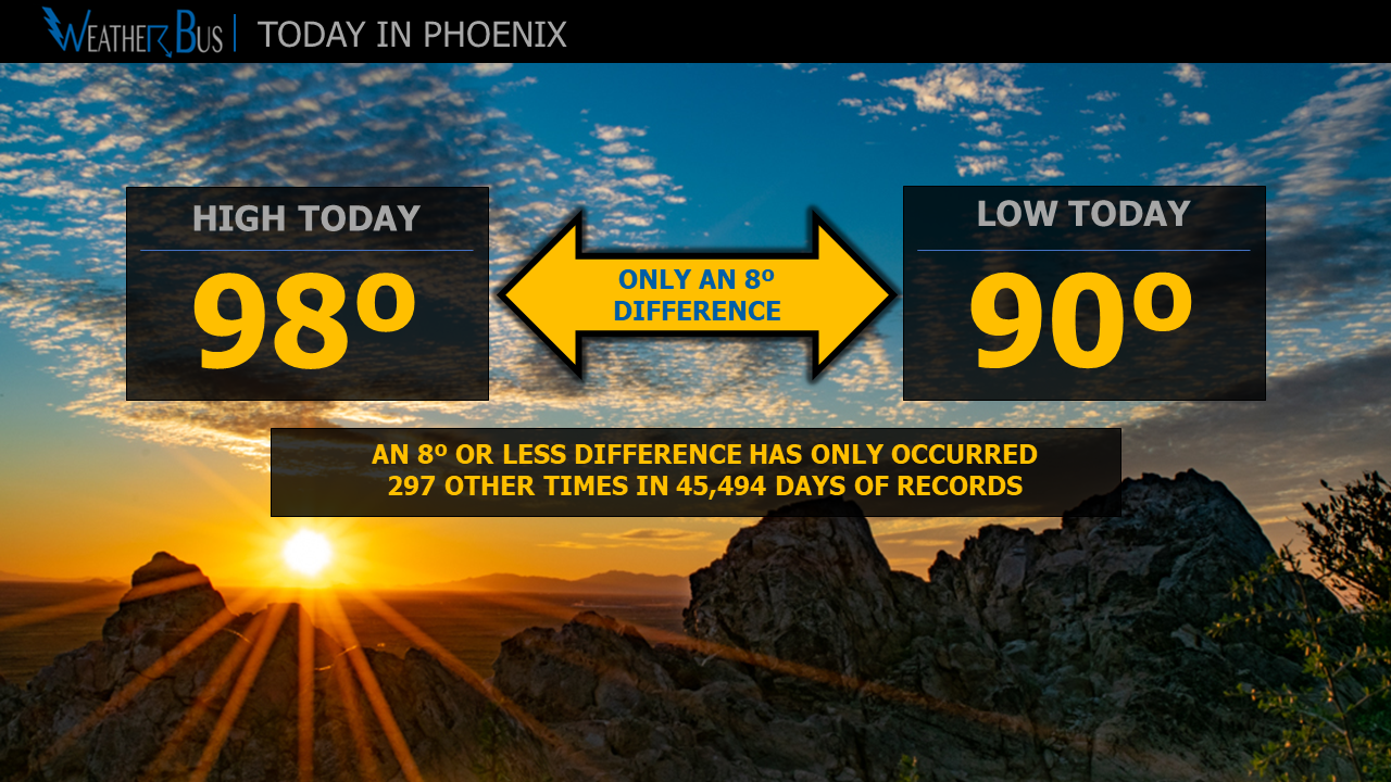
Get ready for a roller coaster! Afternoon high temperatures in Phoenix on Tuesday are forecast to be in the low to mid-70s before skyrocketing into the 100-102º range Saturday.

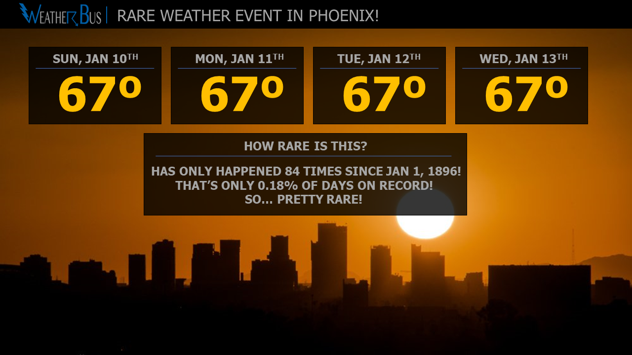
If you are wondering how rare it is to go from the 70s to the first 100-degree day of the year, you have come to the right place.

Looking back over the past 125 years (1896 - 2020), there have only been 16 years when the high temperature in Phoenix was in the 70s, four days or less before the first triple-digit high of the year. Drilling down a bit further, since the high this coming Tuesday is right around 74º, there have only been four years where the high has been 74º or less, just four days before the first 100º reading of the year.

The coolest high temperatures preceding the first triple-digit day of the year are as follow:
Four days before: 70º in 1919
Three days before: 70º in 2001
Two days before: 80º in 1961
One day before: 88º in 2003

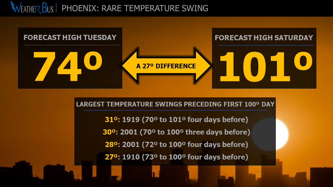
As for the biggest temperature change four days before the first 100º of the year, the current record stands at 31º in 1919, going from a high of 70º to 101º. This year, the forecast high on Tuesday is 74º, and on Saturday, it is 101º, making it a change of 27º, which would tie as the 4th largest temperature swing on record (when comparing the high on the first 100º+ day with the days preceding it).

Record temperature swings preceding first 100º day:
31º: 1919 (70º to 101º four days before)
30º: 2001 (70º to 100º three days before)
28º: 2001 (72º to 100º four days before)
27º: 1910 (73º to 100º four days before) and this year may tie that!

As you can see, the event that is forecast to happen this year in Phoenix is a rare one!

March 26th: Coolest day in Phoenix until next Fall?

- Posted in Weather Facts by

We all know summer is fast approaching, and the closer it gets, a question always comes up: will this be the coolest day until next Fall? After all, the high temperature today (March 26th) in Phoenix was a nice 66º!

The good news, high temperatures have been 66º or cooler past March 26th before. In 1922, the high temperature on May 10th came in at 65º, which is the record for the latest 66º or cooler high temperature (going from Spring into Summer). Also, just last year, the Valley of the Sun recorded a high of 66º on March 27th.

Ok, now to the bad news, so you may want to stop reading if heat makes you uncomfortable. In the past twenty years (2001-2020), the high has only dropped to 66º or below, seven out of those twenty years. That means there is about a 35% chance Phoenix could see the high drop to 66º or lower before summer. If you are more of a glass-half-empty kind of person, there is a 65% chance that March 26th was indeed the coolest temperature the Valley will see until Fall. Even if it is, it is nowhere near the record earliest last 66º or cooler day, that trophy goes to the year 1972 when the last day was Feb 2nd! So remember, it can always be worse!

The graph at the top of this post shows the twenty and thirty-year rolling averages of the percent of years with a high of 66º or lower along with the number of days with a high of 66º or lower per year.

Is the first 80º day in Phoenix getting earlier?

- Posted in Weather Facts by

Phoenix officially hit 80º for the first time this year on Feb 2nd, which is only one day earlier than the 30-year average of Feb 3rd (based on 1981-2010 data). But the comment alway comes up: it feels like it is getting earlier every year.

So... is it? Let's go to the data!

Before we get started, it should be noted that weather observations go back to 1896 in Phoenix. The weather station moved around to a few locations in Central Phoenix from 1896 to 1953. From 1953 onward, it was located at Phoenix Sky Harbor but has moved locations there three times (1953-1994, 1994-2000, and 2000 to present).

Ok, now that we have that out of the way, the graph above depicts the 30-year rolling average, from 1925 to 2021, for the first day Phoenix has recorded 80º+. It also displays the 10-year rolling average to show a bit more detail.

It is quite apparent that yes indeed, based on the 30-year rolling average, the first 80º+ days is getting earlier. In 1925, the average first 80º+ day was Feb 21st, and in 2015 the 30-year rolling average came in at Feb 1st. The 30-year rolling average with this year plugged in comes out to Feb 3rd. (Note: these dates were converted from truncated Julian day)

These data also show that the overall trend is beginning to flatten out, especially compared to the late 1980's into the 1990's.

Will this trend continue? We shall see in the coming years as data comes in.

First measurable rain of 2021 in Phoenix!

- Posted in Weather Facts by

On Tuesday, January 19th, at around 6:17 am, Phoenix Sky Harbor recorded its first measurable rain of 2021! The average first measurable rain for a year, using the 30-year average (1980-2010), is January 12th.

There have been 11 years since 1896 when measurable rain was recorded on January 1st, with the latest-ever first measurable rain in a year being June 7th set back in 1973. The second latest is May 29th set in 1937, and the third latest jumps to March 18th, recorded in 2012.

So has the first day of measurable rain in a year changed over time?

Of course, after all, you are dealing with the weather, which feeds directly into the climate. The graph below shows the first day of measurable rain (in Julian days) and the 30-year rolling average. As can be seen, the latest 30-year average was January 21st in the late 1930s, which was mainly influenced by 1937. The earliest average came in on January 10th in the early 2000s, and since that time, we have been on a slow increase, with the average (including this year) sitting at January 17th.

Something of note, there is no correlation between the first day of measurable rain in a year and the yearly rain total.

Measurable Rain In Phoenix

Phoenix hits a high of 67º for 4th day in a row

- Posted in Weather Facts by

Do you like rare weather events? If so, Phoenix Sky Harbor just experienced one, and you likely didn't even know it!

The high today (Wednesday) in Phoenix was 67º, which is the 4th day in a row with a high temp of 67º. While it might not seem that rare at first glance, let's go to the numbers.

Out of 45,669 days of weather records (since Jan 1, 1986), this is only the 84th time there have been four or more consecutive days with the same high temperature. That's only 0.18% of days! The record stands at six days set in 1928 and 1953. In 1928, the high temperature was 71º from Dec 5th through Dec 10th, and in 1953, the high was 106º from Sept 5th through the 10th.

Phoenix: 2020 Weather Year in Review

- Posted in Weather Facts by

No one will argue that 2020 was an interesting year, and the weather was no different. Here we will breakdown high temperatures, low temperatures, and precip stats for the year and how they compare to average. All data are from 1896 through 2020 (Phoenix long term record) and are referencing the year-long statistic.

Let's start with temperature stats!

Highest high temperature this year: 118º
(ties as the 4th warmest temperature on record)
Record Highest: 122º in 1990
Record lowest high: 109º in 1911

Lowest high temperature this year: 55º
(ties as 3rd warmest lowest high on record)
Record highest lowest high temperature: 58º in 1989
Record lowest high temperature: 36º in 1898

Average high temperature this year: 89.5º
(second warmest on record)
Record highest average high temperature: 89.8º in 1989
Record lowest average high temperature: 81.4º in 1913

Lowest low temperature this year: 35º
(ties as the 3rd warmest low temperature on record)
Record lowest low temperature: 16º in 1913
Record highest losest low temperature: 37º in 1986

Warmest low temperature this year: 94º
(ties as 3rd warmest high low temperature)
Warmest low temperature: 96º in 2003
Lowest high low temperature: 81º in 1915

Average low temperature this year: 64.9
(ties as 3rd warmest)
Highest average low temperature: 65.4 in 2014, 2015, 2017
Lowest average low temperature: 53.2 in 1917

And finally, some precipitation stats:

Total rainfall this year: 5.00"
(27th driest year on record)
Lowest rainfall: 2.82" in 1956 and 2002
Highest rainfall: 19.73" in 1905

Number of days with rain this year: 15
(record fewest - the old record was 18 in 2002)
Most days with rain: 74 in 1905

Most rain in one day this year: 1.04"
(ties as the 35th most)
Most rain in one day: 3.30" in 2014
Least most rain in one day: 0.42" in 1947

We will break down some of these stats in more detail in the next week or so.

Phoenix hits 80º for the second time this December

- Posted in Weather Facts by

The high temperature on December 9th hit 80º at Phoenix Sky Harbor. This temperature is 14º above average for this time of year, and just 4º away from the record of 84º set back in 1981.

This also marks the second December day this year with a high temperature of 80º+. Since 1896, there have only been 15 years (now including this year) that have seen two or more 80º+ days in December.

  • 7 days with 80º+: 1980
  • 5 days with 80º+: 1939, 1940, 1950
  • 4 days with 80º+: 1965
  • 3 days with 80º+: 1938
  • 2 days with 80º+: 1917, 1946, 1949, 1977, 1981, 2003, 2010, 2017, 2020

Looking at the total number of days in the weather record for December, there have only been 63 days out of 3,853 days with a high of 80º+. In other words, these temperatures are reasonably rare.

If you don't like this December "heat", temperatures will drop back into the 60s tomorrow into the weekend as a storm system moves through the state.

Phoenix hits a high of 80º on Dec 7th

- Posted in Weather Facts by

The average high temperature for December 7th is 67º, but this year, Phoenix Sky Harbor hit 80º. The record for the day is 83º, which was set back in 1938.

So how rare are 80º days in December? The last time Phoenix had an 80º+ temperature in December was back in 2017, and before that it was in 2013. Since 1896, when records began in Phoenix, there have been 31 years with a high of 80º+ in December.

Another way to examine how rare this is, look at the total number of days. Out of 3,851 December days on record, only 62 of them have seen a high of 80º+. That's only 1.6% of December days!

The most number of days in December with a high of 80º+ was 7, set back in 1980.

High temperatures are forecast to be right around 80º tomorrow as well, which would make it the 2nd day this year with a high of 80º+ in December. Only 14 years have had 2 or more days with high temperatures of 80º+ in December (see list below).

  • 7 days: 1980
  • 5 days: 1939, 1940, 1950
  • 4 days: 1965
  • 3 days: 1938
  • 2 days: 1917,1946,1949,1977,1981,2003,2010,2017

Phoenix Dry Streak Has Ended!

- Posted in Weather Facts by

Monsoon storms finally moved over Phoenix Sky Harbor just before 7 pm on July 24th, producing 0.10" of rain, breaking the 103 day long dry streak! The last time measurable rain fell at Sky Harbor was April 11th!

So far this year, 3.65" of rain has fallen, which is below the year-to-date average of 3.95".

The radar image above shows how close the storm came from missing the rain gauge at the airport, marked with the red box.

July 23, 2020: Rare Phoenix Temperature Event

- Posted in Weather Facts by

*****NOTE: The temperature after this post was written dropped to 86º at 11:59pm. This means the difference in high/low for the day was 12º, which has happened 1,262 times. Not nearly as impressive as only 297 times.***

If you are looking for a dose of random weather facts, you have come to the right place. Today it's all about the high and low temperature difference! And there is one fact that I think weather nerd or not, you will find interesting!

The high temperature at Phoenix Sky Harbor on July 23, 2020, was 98º, with a low of 90º. That's a difference of just 8º. Having a temperature range that small has only occurred 297 times since records began in 1896. In other words, in 45,494 days of weather records, it has only happened on 0.65% of the days!

Ok, now to the very strange part!

Having an 8º difference has only happened five times in July since records began. Ok, great, not that exciting... well, just wait... out of those five times, three have occurred on July 23rd! Very interesting, don't you think? Slim odds of that happening!

Just in case you were wondering, the largest difference in high and low temperature comes in at 48º, which has occurred twice. On June 13, 1917, the high temperature was 107º with a low of 59º. On April 17, 1919, the high was 96º with a low of 48º!

The smallest difference occurred on February 7, 1941 with a high of 52º and a low of 50, just a two-degree difference!

There you have it, your daily dose of useless weather facts! You may now return to your regularly scheduled programming!

Page 2 of 4